
Gallery of my Favorite Photos
What follows is about 40 of my favorite images from my 2015 motorcycle trip, presented in chronological order. There are not many “selfies” or photos of people in what follows, as I viewed the journey as primarily about the biomes and landscapes of North America. Please enjoy!


Above/Left: A high-level (and only approximate) map of my odyssey.
Below: End-of-Day locations according to my inSight device and GPS.
I departed Alexandria, VA on May 15 (Day 1), and returned August 9 (Day 87).
May 19 (Day 5). The Okefenokee Swamp, Georgia.

Today, the Okefenokee is the largest black-water swamp in North America, but earlier in Earth’s history these were larger and more widespread.
“Black Water” refers not only to how it appears from the surface (due to tannins), but to the fact that it is low in oxygen and thus slowly generating peat. “Swamp” is loosely defined as “forested wetlands.”
May 24 (Day 10). The Everglades, Florida.

This view is from the Shark Valley Observation Tower, near the end of the dry season. In a week or two, all the grassy areas will be under a few feet of water. Just their tips will break the surface, yielding the phrase “River of Grass.” The bushy Hummocks in the distance will appear as islands, as they are a few feet higher in elevation.

May 25 (Day 11). Placid, Florida.
An evening electrical storm over my motel in central Florida.
May 31 (Day 17). The Flint Hills of Kansas.

Photo from the Tallgrass Prairie Nature Preserve in the Flint Hills. In late spring, the grasses are knee-deep. By the end of summer, they will be six to ten feet deep. Two hundred years ago, much of the Great Plains looked like this.
June 2 (Day 19). Ashfall Fossil Beds, Nebraska.

An 11-million-year-old waterhole that was filled in by volcanic ash from an eruption of the Super volcano that is currently under Yellowstone National Park. Entombed are perfectly preserved skeletons of large animals that no longer live here, including rhinos and three-toed horses.
June 3 (Day 20). Badlands, South Dakota.

There are millions of pictures available of South Dakota’s Badlands, but I took this one because I liked the sherbert coloring of this section.
June 7 (Day 24). Wild bison near Devils Lake, North Dakota.

This is from Sully’s Hill preserve near Devils Lake, ND. Just as unusual as the free-roaming bison (no fences!) is the presence of trees in the State of North Dakota. This is due to the presence of water in the form of an unusual Basin Lake.
June 13 (Day 30). Aspen Parkland Biome, northern Alberta.

This photo was taken near the town of High Level, Alberta. The Aspen Parkland biome shown in the distance is a narrow, transitional band between prairie to the south and taiga to the north. It appears very dense, nearly impenetrable. In the foreground is, I believe, a fiber optic cable, just running alongside highway AB 35.
June 14 (Day 31). On the AB-NWT Border.

A vanity shot as I crossed the 60th parallel from Alberta into the Northwest Territories. On a motorcycle. Forgive me.
June 14 (Day 31). Alexandra Falls, NWT.

These falls are not far from the NWT border, along the Hay River. It’s a 32-meter (100 foot) drop. The Hay River eventually flows into the Great Slave Lake, and from there the Mackenzie River and then the Arctic Ocean. A rail line from Edmonton parallels this river, connecting the lake to “southern” Canada.
June 14 (Day 31). The Deh Cho Bridge, NWT.

The Deh Cho Bridge is the ONLY bridge across the Mackenzie River, which is the second largest river (by both length and drainage area) in North America. It was very challenging to build because of its sub-arctic climate, the kinetic nature of “ice breakup season,” and its remoteness. It was only opened to traffic in 2012 (replacing a ferry). It provides a paved, all-season route to Yellowknife, the capital of the Northwest Territories.
June 16 (Day 33). The Deh Cho Highway, NWT.
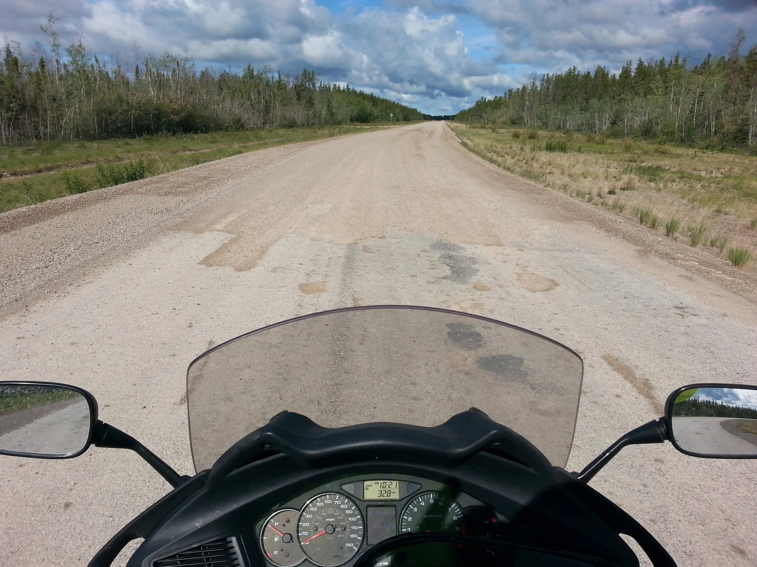
I titled this image “Where the asphalt ends, with apologies to Shel Silverstein.” No gas for 180 miles, and very little pavement for the next 2000 miles. I said something like “Well, this is it!” to myself as I stepped out onto the wire.
This portion of the road was quite ridable, but soon I would run into vast stretches where it felt like the cycle would go down an any moment due to the slick surfaces and loose gravel. I acquired a perpetual layer of adrenaline sweat over my skin surface.
June 16 (Day 33). Taiga Biome, NWT.

This is what the taiga biome looks like, during the brief summer season. Although it is one of the largest biomes on Earth in terms of area, its biodiversity is very low; you see the same few species of trees (and occasionally large animals) for thousands of miles. This is a tough environment to eke out an existence.
June 20 (Day 37). The Yukon River, Yukon Territory.

My first glimpse of the Yukon River from the treacherous Campbell Highway. I was deep in “the zone,” and felt both intensely stressed (due to road conditions and possibly isolation), and also intensely alive.
June 22 (Day 39). Dawson City, Yukon

Front Street in Dawson City, parallel to the Yukon River. The ancient landslide scar on the mountain ahead was a landmark in the gold rush days.
The white structure on the left edge is the Keno, an old steamboat; it is permanently docked on the river.
June 23 (Day 40). Dempster Highway, Yukon

Warning sign at the southern end of the legendary Dempster Highway. At the time, the Dempster ended at Inuvik, some 736 km (457 mi) away, over a famously challenging unpaved road. Hey, at least it’s not raining — or snowing!
The body of water ahead is the Klondike River, a famous tributary of the Yukon River.
June 23 (Day 40). Tombstone Territorial Park, Yukon Territory

Just another spectacular view along the Dempster. The most distant mountain in this image, barely visible, is Tombstone Peak.
June 23 (Day 40). Oglivie Range, Yukon Territory

The Dempster Highway passes through the Oglivie Range north of Tombstone Territorial Park.
This stretch is part of Beringia, an old biome that was never glaciated because it was too dry. Hence the Oglivies are not carved by ice sheets, but only wind and the freeze-thaw cycle of precipitation.
June 24 (Day 41). The Arctic Circle Marker, Dempster Highway, Yukon Territory

It was amazing to be here. The air was “midnight sun” warm, about 70 degrees F. Note how green the background terrain is.
June 25 (Day 42). Pingo near the Arctic Coast, NWT

This is what true tundra looks like in summer. Soft and squishy on top, with permafrost a few feet down. In the distance is a pingo, essentially a giant frost heave, and one of the few landmarks on this landscape. The sky is often hazy due to smoke from the chronic low-level wildfires that occur routinely every summer.
June 25 (Day 42). Tuktoyaktuk (“Tuk”), NWT

The author on a rise (actually a small pingo) overlooking the town of Tuk. That is the Arctic Ocean (!) in the background, and large mosquitos in the foreground. I was on my second or third wind by this time.
June 25 (Day 42). Tundra from the air, NWT

The “Tuk tour” included a boat trip down the Mackenzie River (that is, north), and then a flight back to Inuvik in a small airplane. This is an aerial view is of tundra in summer, with a pingo in the center. The shallow ponds are meltwater which cannot escape because of permafrost. There is no water table here.
June 27 (Day 44). Wet Dempster, Yukon

It rained and rained on the return trip to Dawson City, creating conditions that were well beyond my skill level. It was like trying to ride on slush-covered ice. This was the most brutal riding of the entire journey, and I was completely spent by the end of it.
June 28 (Day 45). Top of the World Highway, Yukon and Alaska

Riding west from Yukon to Alaska on the Top of the World Highway, a summer-only scenic route that stays close to the ridge of a chain of low mountains. My last unpaved road, for which I was very glad.
July 4 (Day 51). Alaskan Tundra from the Air

Karen joined me for a long weekend in Anchorage, and we took an excursion (via 737) to Utqiagvik (formerly Barrow) on the Arctic coast, north of the Arctic Circle again. This photo is a view of what summer tundra looks like from a higher altitude.
July 5 (Day 52). Midnight Sun at Utqiagvik, Alaska

True astronomical Midnight Sun, when the sun is at its lowest point (around 2 a.m. local time). The view is through Utqiagvik’s landmark Whalebone Arch, looking DUE NORTH over the Arctic Ocean and towards the North polar axis. The sun is moving from left to right horizontally in this image, skimming the horizon without ever setting. Magic.
July 11 (Day 58). Northern British Columbia
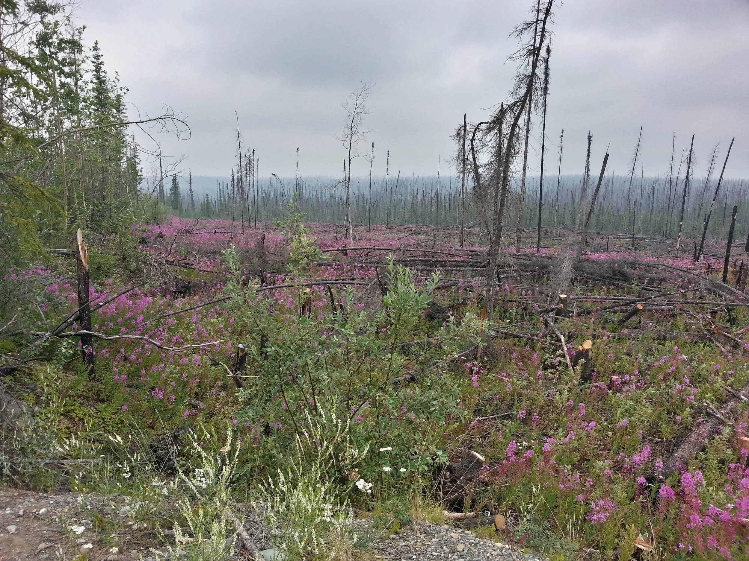
I took this shortly after crossing into British Columbia. I call this photo “Haunted Forest.” The magenta flowers are Fireweed, the official flower of Yukon Territory.
July 15 (Day 62). Lake in the Canadian Rockies.

A typical “emerald” lake in the Canadian Rockies. The color of the water is accurately shown here; the unique green coloring is due to very fine rock particles called “glacial flour” suspended in it, deposited by melting glaciers. The photo was taken on the Alberta side of the BC-Alberta border.
July 20 (Day 67). Southern Idaho road cut

Photo of a weathered road cut near the Idaho-Nevada border, showing alternating layers of lava flows and volcanic ash.
July 21 (Day 68). The Great Basin, Nevada

Typical road scene in the Great Basin in northern Nevada. The mountains could be a mile away, or ten miles away; difficult to tell. This is high desert; very hot during the day, and downright chilly at night.
July 21 (Day 68). Rain Squalls in central Nevada

Along US Route 50, “The Loneliest Road in America,” near the top of one of the many narrow north-south running mountain ranges in the Great Basin. Nevada.
July 22 (Day 69). San Rafael Swell, Utah

Central Utah arguably has the most rugged terrain in the Continental US. Yet, remarkably, we built an Interstate through it. This is from the Spotted Wolf Canyon Overlook on I-70.
July 25 (Day 72). Near Aspen, Colorado

Karen and I selected Aspen, Colorado for our fourth and final Rendezvous. Once there, she found a tour that took us to this fabulous place: Maroon Bells Lake. Life was good.
July 29 (Day 76). Thunder Basin, Wyoming

This is a view of Thunder Basin National Grassland in eastern Wyoming. I rode through this in the morning, to avoid the brutal winds that manifest here every afternoon.
July 30 (Day 77). Black Hills, South Dakota

This image gives a sense, I hope, of the unearthly shapes that wind and the freeze-thaw cycle have carved into the exposed Precambrian rocks of the Black Hills. A magical place, with fabulous riding. Not coincidentally, the Sturgis motorcycle festival is held around here every year.
July 31 (Day 78). Sand Hills of Nebraska

Cows enjoying an exposed portion of the Ogallala aquafer in the Sand Hills region of Nebraska. The hills in the background are “frozen” sand dunes.
August 2 (Day 80). Northern Missouri
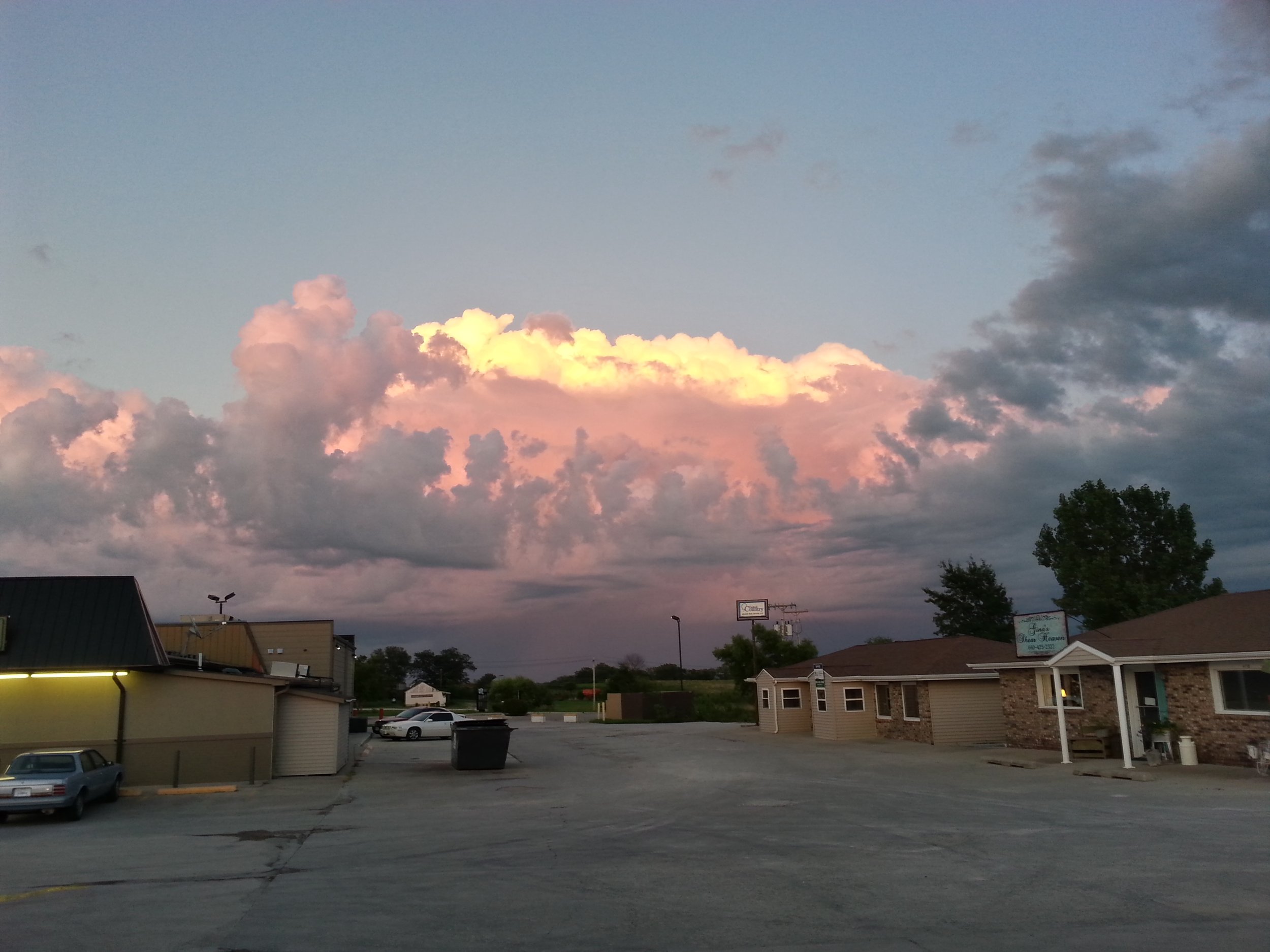
Interesting cloud formation over an otherwise uninteresting Midwestern landscape.
August 9 (Day 87). Steeles Tavern, Virginia

The Blue Ridge Mountains of Virginia, as seen from Steeles Tavern / Raphine. Almost home.
August 9 (Day 87). Charlottesville, Virginia

The (updated) 19th-century observatory on Mt. Jefferson, on the Grounds of the University of Virginia. My own personal hallowed ground.